
Geography of Keoland
Keoland, located in the fertile Sheldomar Valley, is a land of varied terrain bordered by rivers, forests, hills, and marshes. Its geography has played a significant role in shaping the kingdom's economy, culture, and strategic position in the Flanaess.
Major Rivers
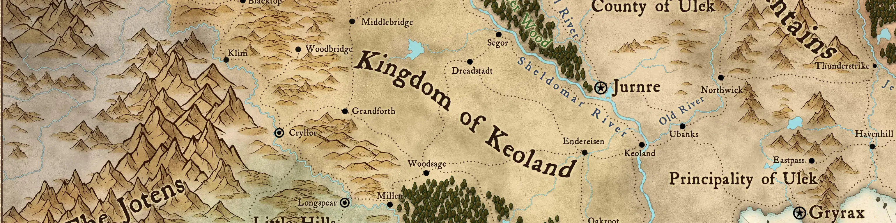
Sheldomar River:
The largest river in Keoland, forming its eastern border with the Ulek States. It flows southward into the Azure Sea, serving as a vital trade route for the kingdom. The Sheldomar River is wide and navigable, fostering trade and commerce.Javan River:
The longest river in the Sheldomar Valley, forming much of Keoland's western border and separating it from the Yeomanry and Sterich. Its upper reaches are swift and rocky, while its lower courses are more placid and navigable.Dunwater River:
Flowing south from the Drowned Forest in the Hool Marshes, the Dunwater River cuts through the southern portion of Keoland. It serves as a local waterway and is often associated with the marshlands' dangers.Kingfisher River:
Running along the eastern edge of the Hool Marshes, the Kingfisher River flows southward and empties near Saltmarsh. It is a vital waterway for the coastal communities, supporting fishing and small-scale trade.Nightshade River:
Emerging from the Dreadwood, the Nightshade River flows eastward and empties into Javan Bay at Seaton. It is named for its dark, shadowy waters and is often associated with the mysterious forest.
Seas, Bays, Marshes, and Wetlands
Azure Sea:
The southern coastline of Keoland lies along this vast and strategically important body of water. The Azure Sea facilitates trade and naval power, with the port cities of Gradsul, Saltmarsh, and Seaton playing key roles.Javan Bay:
Located at the southern end of the Javan River, this bay serves as a critical maritime region for Keoland’s western coast. It is less developed than the Azure Sea coast but still significant for trade and fishing.Hool Marshes:
These vast wetlands cover much of Keoland's southern border, creating a natural barrier between the kingdom and the Sea Princes. The marshes include the Drowned Forest and are home to lizardfolk, smugglers, and dangerous creatures.Rushmoors:
Located in the north, near the border, these moors are less dangerous than the Hool Marshes but are still known for their boggy terrain and the occasional monstrous inhabitant.
Hills and Plains
Good Hills:
Located in northwestern Keoland, the Good Hills are a fertile and forested region inhabited primarily by gnomes and halflings. They are known for their mining, agriculture, and craftsmanship.Fertile Plains:
The heartland of Keoland consists of vast, fertile plains that support the kingdom’s robust agriculture. Wheat, rye, and other grains are the primary crops.Cryllor Foothills:
To the west, near the Javan River, these foothills provide a blend of agricultural and mining opportunities.
Forests
Dreadwood:
Situated in southern Keoland near the Azure Sea, this dense and ancient forest is home to sylvan elves and dark rumors of monsters and magical phenomena. It serves as a natural barrier against incursions from the south.Silverstand Forest:
A small forest located south of the Dreadwood, the Silverstand is home to a mix of elves and other woodland creatures. It is known for its serene beauty and its role as a buffer zone between the Dreadwood and the coastal regions.Drowned Forest:
A swampy forest located within the Hool Marshes, it marks the headwaters of the Dunwater River. The Drowned Forest is shrouded in mist and teems with dangerous creatures, making it a place of mystery and peril.